Characterising the Landscape: Context of the Project
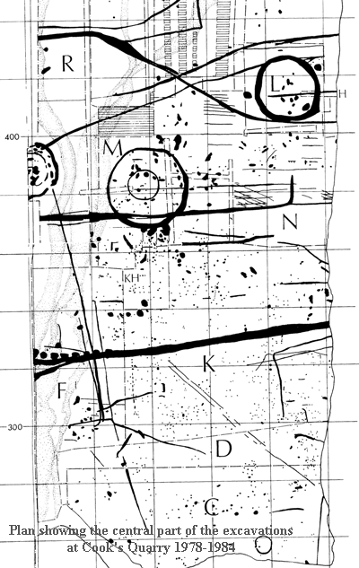
 Excavations took place at and around Cook’s Quarry (Site 1) West Heslerton, between 1978 and 1986, in advance of sand and gravel extraction (funded through the national Rescue Archaeology programme). These revealed a palimpsest of remarkably well preserved features relating to human activity between the Mesolithic and Anglo-Saxon periods (Powlesland et al 1986). The deposits were unusually well preserved due to the presence of blown sands, which had progressively buried ancient land-surfaces, protecting them from the impact of later agriculture. Other major rescue excavations covering more than 25Ha. continued in the vicinity until 2000 when excavation ahead of mineral extraction resumed at Cook’s Quarry; this time funded by the quarry company following the guidelines outlined in planning guidance notice PPG16. Excavations took place at and around Cook’s Quarry (Site 1) West Heslerton, between 1978 and 1986, in advance of sand and gravel extraction (funded through the national Rescue Archaeology programme). These revealed a palimpsest of remarkably well preserved features relating to human activity between the Mesolithic and Anglo-Saxon periods (Powlesland et al 1986). The deposits were unusually well preserved due to the presence of blown sands, which had progressively buried ancient land-surfaces, protecting them from the impact of later agriculture. Other major rescue excavations covering more than 25Ha. continued in the vicinity until 2000 when excavation ahead of mineral extraction resumed at Cook’s Quarry; this time funded by the quarry company following the guidelines outlined in planning guidance notice PPG16.
Although Heslerton is best known for the early Anglo-Saxon evidence recovered during the excavations of the cemetery and associated settlement, the prehistoric evidence is equally important. To quote Terry Manby the leading Yorkshire Wolds prehistorian ‘Heslerton has a far greater cultural richness and depth than most other excavated sites in Britain”.
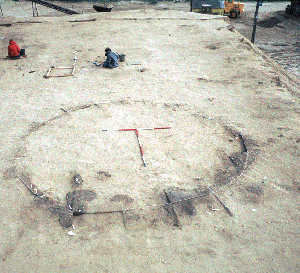
The prehistoric evidence from and around Cook’s Quarry includes a number of Late Neolithic and Early Bronze Age monuments: 1 hengiform, 7 round barrows, a cremation enclosure and a number of major post features representing avenues and part of a post-built cursus. Late Bronze Age and Early Iron Age settlement evidence from Site 1 includes the only extensively excavated area of non-enclosed settlement of this period in the region. This late prehistoric settlement evidence can be linked with the palisaded enclosures of Devils Hill and Staple Howe, situated on the Wolds scarp a kilometre to the south.
Between 1985 and 1999 several hectares of important archaeological deposits were lost at the Quarry without observation, no one knew they were there; since then new arrangements have been made by the quarry company to recover the evidence ahead of destruction. This project is designed to help identify the most important areas of archaeology and use this evidence to help plan mineral extraction in a way that will avoid the most important deposits.
 The geophysical surveys conducted in Heslerton demonstrate that the landscape incorporates a series of linear land use and activity zones, that follow the contours. The results of the survey are nothing short of outstanding. This work whilst revealing the tremendous richness of the buried landscape, showed that the area is under serious threat from agriculture and mineral extraction. More problematically the research reveals that the blown sands, which have afforded a tremendous degree of stratigraphic preservation, are being aggressively denuded whilst restricting the magnetic and air photographic response of major prehistoric features. The blown sand deposits, and the well-preserved archaeological deposits beneath them, extend along the southern margins of the Vale of Pickering, following the valley edge for more than 20km, from Rillington to Staxton. They extend out from the 45m contour for nearly a kilometre, towards the wetlands that once covered the valley floor. Past work has demonstrated that the blown sand cover in the area has buried archaeological occupation surfaces from the Neolithic period onwards in a way that is exceptionally rare thus securing the international reputation of the Heslerton Landscape. The geophysical surveys conducted in Heslerton demonstrate that the landscape incorporates a series of linear land use and activity zones, that follow the contours. The results of the survey are nothing short of outstanding. This work whilst revealing the tremendous richness of the buried landscape, showed that the area is under serious threat from agriculture and mineral extraction. More problematically the research reveals that the blown sands, which have afforded a tremendous degree of stratigraphic preservation, are being aggressively denuded whilst restricting the magnetic and air photographic response of major prehistoric features. The blown sand deposits, and the well-preserved archaeological deposits beneath them, extend along the southern margins of the Vale of Pickering, following the valley edge for more than 20km, from Rillington to Staxton. They extend out from the 45m contour for nearly a kilometre, towards the wetlands that once covered the valley floor. Past work has demonstrated that the blown sand cover in the area has buried archaeological occupation surfaces from the Neolithic period onwards in a way that is exceptionally rare thus securing the international reputation of the Heslerton Landscape.
This project has been designed to build on the evidence accrued from 25 years of research around Heslerton and develop the resources needed to proactively secure the future of the past. The results of the project should mean that never again are we faced with an unexpected discovery of a cemetery or other major complex during minerals extraction.
Next Section: Objectives
|

 Excavations took place at and around Cook’s Quarry (Site 1) West Heslerton, between 1978 and 1986, in advance of sand and gravel extraction (funded through the national Rescue Archaeology programme). These revealed a palimpsest of remarkably well preserved features relating to human activity between the Mesolithic and Anglo-Saxon periods (Powlesland et al 1986). The deposits were unusually well preserved due to the presence of blown sands, which had progressively buried ancient land-surfaces, protecting them from the impact of later agriculture. Other major rescue excavations covering more than 25Ha. continued in the vicinity until 2000 when excavation ahead of mineral extraction resumed at Cook’s Quarry; this time funded by the quarry company following the guidelines outlined in planning guidance notice PPG16.
  The geophysical surveys conducted in Heslerton demonstrate that the landscape incorporates a series of linear land use and activity zones, that follow the contours. The results of the survey are nothing short of outstanding. This work whilst revealing the tremendous richness of the buried landscape, showed that the area is under serious threat from agriculture and mineral extraction. More problematically the research reveals that the blown sands, which have afforded a tremendous degree of stratigraphic preservation, are being aggressively denuded whilst restricting the magnetic and air photographic response of major prehistoric features. The blown sand deposits, and the well-preserved archaeological deposits beneath them, extend along the southern margins of the Vale of Pickering, following the valley edge for more than 20km, from Rillington to Staxton. They extend out from the 45m contour for nearly a kilometre, towards the wetlands that once covered the valley floor. Past work has demonstrated that the blown sand cover in the area has buried archaeological occupation surfaces from the Neolithic period onwards in a way that is exceptionally rare thus securing the international reputation of the Heslerton Landscape.