Characterising the Landscape: Sampling procedures and observation trenches
To fully assess the results of this survey will take many years and is beyond the scope and objectives of this piece of this research. Excavation work was restricted to an experimental piece of top-soil sieving, the excavation by machine of a series of observation trenches followed by a rapid cleaning and basic documentation to determine the level of preservation and basic dating of the buried deposits and to the examination of a small number of features to determine their nature and date.
The top-soil sieving programme: an alternative to surface finds collection
 
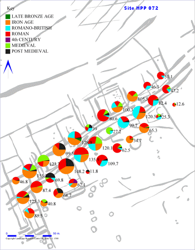
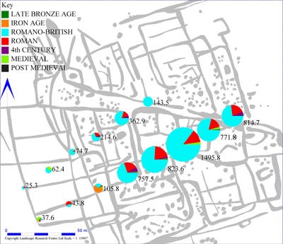
The results of the topsoil sieving programme expressed using pie charts. These reflect the weight of ceramics by period. The data range from Site 128 is such that the pie sizes are set at about a quarter of the scale of those from Site 72; in this format the two data sets are not graphically comparable.
Field-walking or surface collection surveys are frequently used as a method of site assessment in rural archaeology; working on the principal that material ploughed up from archaeological sites beneath the plough-soil can be gathered up from the surface of the fields and plotted to reveal buried activity areas. As a method of assessment this is very random, we have observed one field that following a deeper ploughing was covered with material however the following years when it was ploughed less deeply almost nothing could be seen on the surface.
The increasing pace of modern agriculture, the use of direct drilling and changes in agricultural machinery mean that opportunities for field-walking are also more restricted. In the past, when a field would be harvested and ploughed and then left for some weeks before harrowing and planting, this left time for weathering to expose more material making it more visible. Top-soil sieving offers a more secure and more scientific approach to the assessment of the plough-soil; by using 1m square trenches and recording the volume of material sieved comparative statistics can be generated. As an experiment, sets of sample trenches were hand dug to the base of the plough-soil and their contents sieved on two different sites (072 and128) just over a kilometer apart.
The two images show the results of the topsoil sieving programme, giving the weight of ceramics recovered normalized so that the pie chart sizes reflect both weight of ceramics and volume of material sieved allowing different fields to be compared. Site 128, which is dominated by large weights of later Roman material reveals an immensely important occupation site which is actively suffering from plough damage. The samples retrieved reflect both variability in the density of domestic or industrial activity and the varying degree of preservation across the site; the pie charts reflecting small counts occur in better preserved parts of the field.
The discovery in an observation trench of quantities of unfired clay with calcite mixed-in indicates that this was a pottery manufacturing site, as such it is a unique discovery in this region. Although this complex has been badly damaged, during the last decade, areas with preserved deposits remain where the blown sand cover is thicker. The lower weight to volume ratios and the more mixed assemblage from Site 72 reveal a site that is being less actively damaged and reflects a broader chronological range. Relatively high densities of worked flints, from Neolithic and earlier assemblages, may point towards early settlement on the edge of the wetlands in this part of Site 72. It is clear that this sampling approach offers a more secure basis for site assessment than conventional surface retrieval methods.
Observation Trenches
The exceptionally dry weather during the Autumn made excavation very difficult. It had been envisaged that by opening a series of observation trenches by machine we would be able to assess the reliability of the auger survey and view the depths of plough-soil and blown-sand and enhance the subsurface modelling data, this approach worked well. However, the feeling that we would be able to recover sufficient material from the tops of features to establish the dates of these features proved less successful. A small number of features were excavated to obtain secure dating evidence and determine the condition of the buried deposits. As an evaluation exercise constrained by minimal resources for excavation the fills of the excavated features were sieved to recover dating evidence, this was effective but still, in case of two large and most likely Neolithic pits, did not necessarily produce the sought after dating evidence. A single Iron Age grave was excavated to identify the degree of bone preservation, in this case only the tooth caps survived.
|
