
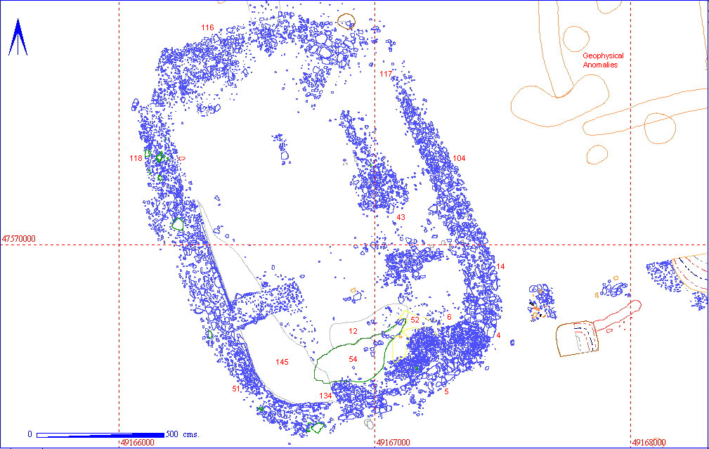
The structure measured 16.15 m in the north-south axis, and 11.36 m in the east-west axis, and has an orientation of 21 degrees (anti-clockwise from the north, assuming true north at 0 degrees). The straight sides and flattened or rounded ends are unusual (? parallels Beadlam Villa and site on the Wolds excavated in early 19th century ?)
Only 29 fragments of tile were found in the vicinity of the structure, 19 of which were clustered in a group just outside the south-east corner. While the small number of tiles does not preclude the possibility that the structure had a tiled roof, it this was the case then the tiles were very efficiently removed from the immediate vicinity when the structure was demolished.
12 iron nails were found within the structure, but this is not an unusual concentration for this type of object (a much higher concentration was noted in area 12AG just to the south, for instance), and again appears to have no structural significance.
| TYPE | CONTEXT | VOLUME | OBJECTS | AN BONE | DENSITY |
| FOOTING | 012AF00004 | 0 | 0 | ||
| FACED WALL | 012AF00005 | 9 | 0 | ||
| RUBBLE | 012AF00006 | 5 | 1 | ||
| UNDEFINED FILL | 012AF00010 | 133 | 10 | ||
| LAYER | 012AF00011 | 31 | 0 | ||
| FLOOR LAYER | 012AF00012 | 1 | 1 | ||
| LAYER | 012AF00013 | 12 | 1 | ||
| WALL MATRIX | 012AF00014 | 21 | 1 | ||
| WALL FOOTING | 012AF00043 | 0 | 0 | ||
| RUBBLE | 012AF00044 | 17 | 1 | ||
| RUBBLE | 012AF00045 | 0 | 0 | ||
| LAYER | 012AF00050 | 13 | 2 | ||
| FACED WALL | 012AF00051 | 0 | 0 | ||
| GRAVEL LAYER | 012AF00052 | 1 | 0 | ||
| UNDEFINED FILL | 012AF00053 | 4 | 1 | ||
| WALL MATRIX | 012AF00116 | 1 | 0 | ||
| WALL MATRIX | 012AF00117 | 0 | 0 | ||
| WALL MATRIX | 012AF00118 | 2 | 0 | ||
| LAYER | 012AF00132 | 27 | 1 | ||
| RUBBLE | 012AF00133 | 1 | 0 | ||
| RUBBLE | 012AF00134 | 0 | 1 | ||
| RUBBLE | 012AF00135 | 15 | 4 | ||
| INTERFACE | 012AF00136 | 103 | 19 | ||
| UNDEFINED FILL | 012AF00139 | 7 | 1 | ||
| LAYER | 012AF00143 | 38 | 2 | ||
| LAYER | 012AF00144 | 0 | 0 | ||
| FLOOR | 012AF00145 | 0 | 0 | ||
| ROBBER TRENCH | 012AF00146 | 0 | 0 | ||
| SPIT | 012AF00009 | 20 | 1 | ||
| SPIT | 012AF00103 | 30 | 3 | ||
| SPIT | 012AF00104 | 74 | 4 | ||
| SPIT | 012AF00106 | 8 | 3 | ||
| SPIT | 012AF00108 | 15 | 1 | ||
| SPIT | 012AF00113 | 8 | 0 | ||
| SPIT | 012AF00114 | 0 | 0 | ||
| SPIT | 012AF00115 | 0 | 0 | ||
| SPIT | 012AF00131 | 190 | 10 | ||
| SPIT | 012AF00152 | 7 | 1 |
| KEY_ID | TYPE | SHAPE | L | B | D | PROFILE | NOTES |
| 012AF00004 | FOOTING | SEMI-CIRCULAR |
310
|
105
|
28
|
WALL FOOTING OF CHALK BLOCKS. MAY BE PART OF AN APSIDAL STRUCTURE. | |
| 012AF00005 | FACED WALL | LINEAR |
150
|
32
|
22
|
WALL LINE OF CHALK BLOCKS. ROBBED IN ANTIQUITY CAUSING DESTRUCTION RUBBLE LAYER 00006. | |
| 012AF00043 | FOOTING | LINEAR |
58
|
32
|
22
|
POSSIBLE WALL FOOTING UNCOVERED BY REMOVAL OF 11. REQUIRES FURTHER DEFINITION. | |
| 012AF00051 | FACED WALL | LINEAR |
304
|
45
|
5
|
FACED WALL AT THE WEST END OF THE TRENCH. APPARENTLY SET INTO A TERRACE CUT INTO THE CHALK NATURAL. SEE NOTES FOR FURTHER DETAILS. |
| KEY_ID | TYPE | SHAPE | L | B | D | PROFILE | NOTES |
| 012AF00014 | WALL MATRIX | LINEAR |
430
|
138
|
22
|
SOIL MATRIX OF WALL FOOTING 00004. CONTAINED 3 SHERDS OF POT TWO OF WHICH WERE SAMIAN. | |
| 012AF00116 | WALL MATRIX | CURVILINEAR |
970
|
100
|
2
|
UNDULATING | CONSTRUCTION MATRIX BONDING WALL FOOTINGS OF NORTH WALL OF BUILDING. CONTAINED COIN OF CONSTANTINE. |
| 012AF00117 | WALL MATRIX | RECTANGULAR |
780
|
130
|
12
|
FLAT | MATRIX COVERING RUBBLE LAYER TO SOUTH/INSIDE NORTH WALL. |
| 012AF00118 | WALL MATRIX | RECTANGULAR |
580
|
700
|
3
|
FLAT | MATRIX LYING BETWEEN WESTERN WALL AND CHALK TERRACE. |
| KEY_ID | TYPE | SHAPE | L | B | D | PROFILE | NOTES |
| 012AF00006 | DESTRUCTION RUB | AMORPHOUS |
375
|
142
|
23
|
IRREGULAR | DESTRUCTION RUBBLE LAYER OVERLYING WALL FOOTING 00004. CONTAINED A NUMBER OF LATE ROMAN POT SHERDS. |
| 012AF00044 | DESTRUCTION RUB | COMPLEX |
129
|
86
|
12
|
IRREGULAR | CONTEXT ISSUED TO WALL RUBBLE. ALMOST CERTAINLY = RUBBLE LAYER 45. |
| 012AF00045 | DESTRUCTION RUB | COMPLEX |
332
|
271
|
13
|
IRREGULAR | WALL RUBBLE AT WESTERN EDGE OF TRENCH. CONTAINS LATE ROMAN POTTERY. SEE NOTES FOR FURTHER DETAILS. |
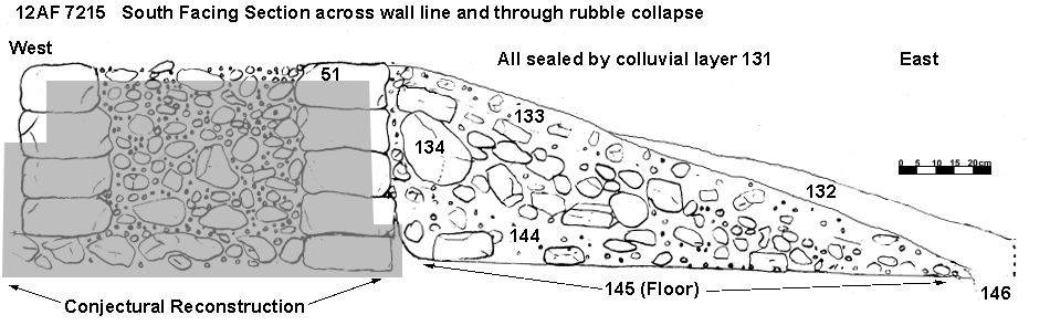
| 012AF00133 | RUBBLE? | LINEAR |
328
|
217
|
28
|
IRREGULAR | WALL RUBBLE ON INTERIOR OF WESTERN LONG AXIS OF LATE ROMAN STRUCTURE. MORTAR IS VISIBLE IN THE RUBBLE DISTINGUISHING IT FROM LAYER 134 BELOW. |
| 012AF00134 | RUBBLE? | LINEAR |
271
|
185
|
22
|
IRREGULAR | WALL RUBBLE ON INTERIOR OF SOUTHERN SHORTER WALL OF LATE ROMAN BUILDING. DISTINGUISHED FROM 133 ABOVE BY CONTAINING LARGER WALL FACING BLOCKS. |
| 012AF00135 | RUBBLE? | UNCLEAR |
139
|
120
|
5
|
IRREGULAR | POSSIBLE MIXED RUBBLE DESTRUCTION? MATERIAL. DARK IN COLOUR WITH FINDS OF A LARGE QUANTITY OF ANIMAL BONE AND POTTERY. |
| KEY_ID | TYPE | SHAPE | L | B | D | PROFILE | NOTES |
| 012AF00009 | SPIT | RECTANGULAR |
497
|
300
|
40
|
TRENCH EXCAVATED TO ESTABLISH LEVEL OF NATURAL. STOPPED WHEN AN OBVIOUS FEATURE BECAME VISIBLE. | |
| 012AF00103 | SPIT | RECTANGULAR |
500
|
280
|
5
|
FLAT | CLEANING SPIT IN TRENCH 2. EXPOSING WALL AND FLOOR AREA. POTTERY COIN IRON NAIL PEDESTAL BASE. SOIL REMOVED WAS HILLWASH MATERIAL. |
| 012AF00104 | SPIT | COMPLEX |
450
|
70
|
2
|
IRREGULAR | SOIL MATRIX OF RUBBLE WALL EXPOSED BY CLEANING SPIT 103. POTTERY TILE IRON NAIL WAS FOUND. |
| 012AF00106 | SPIT | RECTANGULAR |
550
|
280
|
55
|
UNDULATING | CLEANING SPIT IN TRENCH 2 TO REMOVE HILLWASH AND DEFINE BEDROCK AND THE RELATIONSHIP BETWEEN IT AND BACK WALL OF BUILDING. SOME POTTERY. |
| 012AF00108 | SPIT | RECTANGULAR |
1730
|
136
|
5
|
FLAT | CLEANING SPIT OVER REST OF BUILDING. AREA BETWEEN TRENCHS2 AND 3. REMOVED BY MACHINE AND FINDS BAGGED BEFORE SHOVELLING. |
| 012AF00113 | SPIT | CURVILINEAR |
970
|
100
|
17
|
FLAT | CLEANING SPIT TO DEFINE NORTHERN WALL OF BUILDING. |
| 012AF00114 | SPIT | LINEAR |
850
|
150
|
12
|
FLAT | CLEANING SPIT TO DEFINE EASTERN WALL OF BUILDING. CONTAINED POT IRON AND OCCASIONAL BONE. |
| 012AF00115 | SPIT | LINEAR |
970
|
140
|
20
|
UNDULATING | CLEANING SPIT TO DEFINE WESTERN WALL OF BUILDING AND COLLAPSED RUBBLE ON INSIDE OF WALL. |
| 012AF00131 | SPIT | RECTANGULAR |
1369
|
889
|
5
|
COMPLEX | REMOVAL OF REMAINING COLL. FROM INTERIOR OF FLATTENED APSE STRUCTURE. AREA THUS DEFINED BY WALL LINES. |
| 012AF00152 | SPIT | RECTANGULAR |
315
|
194
|
5
|
SPIT TAKEN DOWN TO DEFINE POSSIBLE ENTRANCE TO BUILDING. UNCOVERED PIT 153. |
| KEY_ID | TYPE | SHAPE | L | B | D | PROFILE | NOTES |
| 012AF00010 | UNDEFINED FILL | LINEAR |
403
|
130
|
13
|
UNDEFINED FEATURE CUTTING THROUGH FLOOR 00012. CONTAINED LARGE SHERDS OF UNABRADED POTTERY. | |
| 012AF00053 | UNDEFINED FILL | LINEAR |
271
|
95
|
10
|
DIFFERENT TO FILL 10 BY BEING LIGHTER WITH MORE CHALK INCLUSIONS. SIMILAR HIGH LEVEL OF POTTERY TO 10 WITH MORE ANIMAL BONE. | |
| 012AF00139 | UNDEFINED FILL | LINEAR |
183
|
171
|
22
|
UNDEFINED FEATURE. CONTAINED LARGE QUANTITY OF FRAGILE POTTERY AND SOME ANIMAL BONE. A POST DESTRUCTION EVENT. | |
| 012AF00054 | UNDEFINED CUT | LINEAR |
379
|
94
|
23
|
NOT FULLY EXCAVATED IN INITIAL EXCAVATION PHASE. AN UNDEFINED FEATURE WHICH CONTAINED MUCH LATE ROMAN EASILY DECAYING POTTERY. |
| KEY_ID | TYPE | SHAPE | L | B | D | PROFILE | NOTES |
| 012AF00011 | LAYER | AMORPHOUS |
292
|
300
|
10
|
AREA OF DARKER SOIL BENEATH THE HILLWASH. OVERLIES FLOOR 00012. CONTAINED ANIMAL BONE AND POTTERY. | |
| 012AF00013 | LAYER | LINEAR |
231
|
111
|
5
|
DARKER AREA OF SOIL. CONTAINS POTTERY AND BONE. | |
| 012AF00132 | LAYER | UNCLEAR |
315
|
271
|
15
|
LAYER OF DARKER MATERIAL SEALING BASE OF 133. POSSIBLY = 11. CHARCOAL FLECKING THROUGHOUT. FINDS OF POTTERY AND ANIMAL BONE. |
| KEY_ID | TYPE | SHAPE | L | B | D | PROFILE | NOTES |
| 012AF00012 | FLOOR LAYER | LINEAR |
362
|
72
|
5
|
POSSIBLE FLOOR. CUT BY DITCH 00010. CONTIGUOUS WITH CHALK GRAVEL AND PEA GRIT. FINDS OF A FEW SHERDS OF POTTERY. | |
| 012AF00052 | GRAVEL LAYER | UNCLEAR |
304
|
273
|
2
|
GRAVEL AND PEA GRIT APPARENTLY CONTIGUOUS WITH FLOOR LAYER 12. CUT BY 53/54. UNDERLIES LAYER 11 AND RUBBLE SPREAD 6. | |
| 012AF00145 | FLOOR | UNCLEAR |
879
|
215
|
0
|
FLOOR LEVEL EXPOSED BY REMOVAL OF DESTRUCTION LAYER 144. POSSIBLY CUT BY ROBBER TRENCH 146. |
| KEY_ID | TYPE | SHAPE | L | B | D | PROFILE | NOTES |
| 012AF00050 | LAYER | RECTANGULAR |
210
|
252
|
5
|
FLAT | LAYER OF SANDIER MATERIAL. CHALK INCLUSIONS OF 50% (1 TO 4 CM IN DIAM). FINDS INCLUDE POTTERY AND ANIMAL BONE. |
| 012AF00136 | INTERFACE | UNCLEAR |
250
|
159
|
2
|
FLAT | CONTEXT NUMBER GIVEN TO INTERFACE TO DISTINGUISH FINDS OF 132 FROM 135. |
| 012AF00143 | LAYER | UNCLEAR |
300
|
153
|
10
|
MIXED HILLWASH MATERIAL OVERLYING WALL COLLAPSE 134. EQUALS LAYER 135. SEE NOTES FOR CONTINUATION. | |
| 012AF00144 | LAYER | UNCLEAR |
372
|
193
|
15
|
MATERIAL OVERLYING FLOOR LEVEL 145. THICKER AGAINST THE WALL THINNING AS IT EXTENDS OUT INTO THE BUILDING AREA. |
| KEY_ID | TYPE | SHAPE | L | B | D | PROFILE | NOTES |
| 012AF00146 | ROBBER TRENCH? | LINEAR? |
69
|
23
|
0
|
NUMBER GIVEN OUT TO POSSIBLE ROBBER TRENCH. NOT EXCAVATED. |