![]()
Dedicated to research into the Landscape Archaeology of Eastern Yorkshire
|
Dedicated to research into the Landscape Archaeology of Eastern Yorkshire
|
|
|
Georeferencing the multi-spectral imageryIt was decided at the outset of the project that all multi-spectral image files would be georeferenced using a single data source, in this case the raster image Getmapping files. Getmapping.com provide colour vertical photographs of the entire mainland of Great Britain. Originally part of an ambitious millenium project in the spirit of Domesday to record the entire landscape of Britain at a given moment in time (in this case the year 2000), Getmapping can provide a colour vertical photographic image of any area on the British mainland. The georeferencing of the images is based on the Ordnance Survey grid. The LRC have obtained an academic license to use the Getmapping images of 500 square kilometres covering much of the eastern end of the Vale of Pickering and parts of the Yorkshire Wolds.
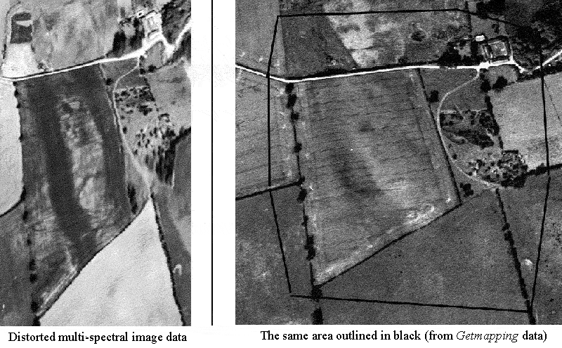
Georeferencing the 1992 multi-spectral imageryGeoreferencing
the June 1992 multispectral images provided a number of problems, not
least the fact that at this time no on board navigational correction
data was collected for the imagery. Also, some of the data was very
distorted, particularly where the foot of the Wolds meets the Vale (see image
below).
This was caused by a number of factors influenced by the attitude
of the plane, including pitch, yaw and height above ground variation. In
addition, as the data was collected by the scanner in an across track
swath mode, the pixels nearer the edge of the runs were more prone to
distortion than those towards the centre of the image. This can clearly
be seen in the image above, where the whole area, and in particular the
eastern edge, is very distorted. The distortion was exacerbated as this
is the point where the Wold scarp meets the Vale, and maintaining an
even altitude becomes difficult.
Software and rectification techniquesThe software used to georectify the multi-spectral images was ERDAS Imagine (versions 8.4 and 8.7). A number of different warping facilities are possible using Imagine, including polynomial and rubber sheet warps. Rubber sheet warping is recommended for datasets which are very distorted, and where a large number of ground control points, particularly around the edges, can be collected. After
much testing, we found that using the rubber sheet method of warping,
combined with a nearest neighbour resampling method, provided the most
accurate means of georeferencing the June 1992 multispectral dataset.
Although bicubic spline resampling provided a smoother look to the
image, no enhanced anomaly detection was derived from this method, and
using the nearest neighbour resampling method has the advantage of not
introducing new digital number
(DN) values into the data. It is
important not to let Imagine choose the pixel resolution at this point,
as it tends to choose a higher resolution than the original data. The
pixel resolution can be set in the final warping dialogue; for this
dataset 1.5 metres per pixel. Due to the extreme image distortion in
some of the runs, particularly near the edges, it was not always
possible to get a perfect georeferenced match with the base map.
However, although some of the features near the edges of the rectified
images were up to seven metres away from the equivalent features visible
on the georeferenced aerial photographs, within the central region of
the warped image virtually all of the anomalies were within the original
pixel resolution (ie less than a two metre difference) in terms of
error, and many were virtually an exact match.
Ground control points
|
Copyright © 2006 The Landscape Research Centre Ltd. Registered Charity No. 326710 All rights reserved.
|