Resistivity
Resistivity is an active form of geophysical surveying, in that an electrical current is applied through probes which must be inserted into the ground, with the electrical resistance to the current then being measured.
The electrical resistance of the ground is almost entirely dependent upon the amount and distribution of water (or moisture) within the soil (Clarke, 1996). In fact, soil and the stones within the soil are insulators, and the current is carried by positive and negative ions in the moisture (or rather the hydrogen ions within the water) present in the pores of the soil, with conductivity increasing with porosity (Keary and Brooks, 1991, 148-218). Features underground which may equate to differences in the soil resistance can be detected with resistivity meters. In particular, stone is generally moisture resistant, and will thus generate a higher resistance signal, so that archaeologists have generally favoured the use of resistivity meters to detect the location of buried stone or masonry walls. Because of its dependence on soil moisture content, resistivity surveys will produce different results at different times, with a decrease in resistance values either during heating or after rainfall (Scollar, 1990, 354)
The principles and concepts behind measuring electrical resistance are well understood (Scollar, 1990, 307-335; Clark, 1996, 27-30), but I include here a brief description of the methods generally used in archaeological prospection.
When measuring the current between just two probes, the problem arises that the contact resistance of the probes is higher than the lower resistance changes in the underlying soil in which the archaeologist is interested. This is because the probe’s surface area is much smaller than the volume of ground through which we are passing the current, and is exacerbated by the fact that the soil’s conductivity is generally poor near the surface, exactly where we need to insert our probes.
This can be overcome by using a four probe system, where two probes (the mobile probes) provide the current and another two (the remote probes), provide a background reading (measuring the voltage gradient). Known as the twin electrode configuration, this system has dominated resistivity surveying for archaeological purposes, although four probe configurations such as the Wenner array or the double-dipole arrangement are now being used with increasing frequency. The separation of the probe pairs in the twin electrode configuration must conform to a strict ratio (a distance of at least 30 times the separation of the probes in the mobile pair, (i.e. a 50cm separation in the mobile probes means that the remote probes must be at least 15 metres away) so that variations in the separation of the pairs will affect readings by less than 3 per cent. This is generally assumed to be a reasonable level for archaeological surveying.
All of the resistance surveys in the project area have been carried out using a Geoscan Research RM15 resistance meter, using the twin electrode configuration. The data collection was carried out using the same system as for the fluxgate gradiometer; that is in 30 metre grids using a zigzag traverse. Data was collected at 1 metre intervals in both north-south and east-west axes, thus collecting 900 readings per 30 metre grid. Generally, the resistivity meter was set up at 1mA, with a gain setting of 1, with the mobile probes spaced 50cm apart.
A further development in resistivity technique is in the application of the principles of tomography, to obtain a vertical cross-section. A linear array of electrodes provides a large number of independent readings, which in turn includes the potential for much greater depth penetration.
Although the multiplexor has been tested at Heslerton (survey carried out by LRC personnel, data processed by EH), the results were inconclusive, possibly because the buried remains were too deep to be detected.
While no form of remote sensing can truly be said to be a repeatable experiment, this is particularly true of resistivity, because of its reliance on the moisture content within the soil to provide results. A site can be surveyed a number of times, with each successive survey giving a different response. Generally, the survey should be carried out a number of days (or weeks, depending on how well drained the site is), after rain, but before all of the soil moisture has dissipated, thus allowing a contrast to be recorded. Spring is normally a good time for resistivity, but not if there has been a high winter and early spring rainfall.
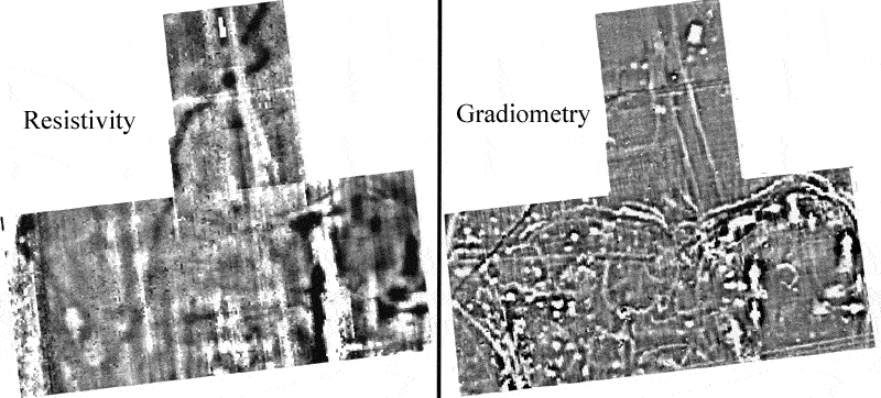
The image below shows the complementary nature of different forms of remote sensing. Although the results from the gradiometer indicate a much higher level of activity, the resistance data adds clarity to some of the magnetic anomalies, as well as detecting features which are not present in the magnetic data. The resistance survey was carried out in far from ideal conditions, in the middle of the hottest July on record (2006), so further tests at a more propitious time for resistance survey could well enhance the level of detail we might expect.