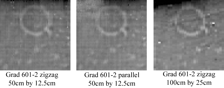
On 29/03/2006, the
Bartington gradiometer was used to collect a set of high resolution data
over a small round barrow on site 002. The site had previously been
surveyed (April 2003) at the normal resolution of 100cm by 25cm, but
prior to a small trial excavation it was believed that a higher
resolution survey could help to confirm the presence of a small entrance
into the monument, aligned to the south-east.
A slightly different methodology was adopted for the dual sensor survey. Two 30m grids of data were collected, with a sample resolution of 50cm east-west and 12.5cm north-south. It has often been stated that better quality data is collected by using the parallel traverse method of data collection, rather than a zigzag method. While it is true that while using a parallel traverse the offset errors are minimised because the operator is walking in the same direction, and heading errors are diminished because the machine is pointing in the same direction, it was believed that a skilled operator could carry out a zigzag traverse with minimal errors in the data collection. To test this, one grid was collected using a zigzag traverse, and the second grid using a parallel traverse.
As indicated above, a very similar result was obtained by both traverse methods, confirming that the zigzag method is the equal of the parallel method, at least in the hands of an experienced operator. It is also unmistakable that the combined effects of higher resolution sampling in both directions gives a much more clearly defined picture of the shape of the barrow ditch, as well as confirming the presence of the entrance. The definition of a number of faint anomalies surrounding the monument was also improved.
The two high resolution grids were offset by 25cm in the east-west axis, in order to allow them to be interleaved, forming a composite 25cm by 12.5cm resolution 30m grid. This involved the collection of 28800 readings for a single 30 meter grid.