High resolution magnetic surveying
The de facto standard for magnetic surveying is currently at 25cm samples in the walking direction using 1 metre traverses. This gives a reasonable balance between anomaly detection and the time taken to collect the survey data. However, at specific times during the last 16 years (see table below for details) the LRC has had the opportunity to test higher resolution surveying over areas of known archaeological potential.
|
Site |
Date |
Area |
Resolution
X |
Resolution
Y |
Method |
Sensitivity |
|
Site 011BA |
July
1991 |
0.186 |
25cm |
25cm |
Zigzag |
0.1 nT |
|
Site 011BD |
September
1991 |
0.045 |
50cm |
25cm |
Parallel |
0.1 nT |
|
Site 011BE |
September
1991 |
0.146 |
50cm |
25cm |
Parallel |
0.1 nT |
|
Site 011BF |
January
1992 |
0.088 |
50cm |
25cm |
Parallel |
0.1 nT |
|
Site 012 |
April
1995 |
1.44 |
25cm |
25cm |
Zigzag |
0.1 nT |
| Site 010 | May 2002 | 0.25 |
25cm |
25cm |
Zigzag |
0.1 nT |
| Site 063 | October 2002 | 0.18 |
25cm |
25cm |
Zigzag |
0.1 nT |
| Site 002 | March 2006 | 0.09 |
25cm |
12.5cm |
Parallel and Zigzag |
0.1 nT |
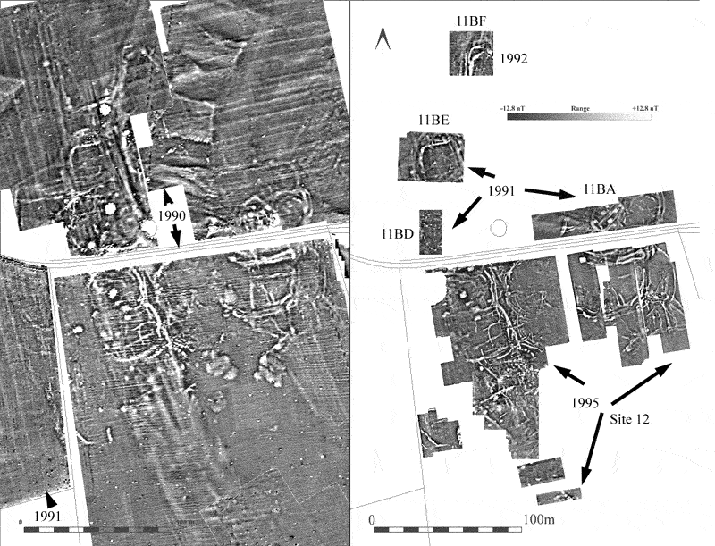
The first tests were carried out in 1991 (see image below for location) and early in 1992 by Tim Carew, over 4 areas covering a total of 0.465 hectares. All of these surveys were conducted with an FM36 after the removal of the topsoil, but remaining above the archaeological strata, with the features sealed by a thin layer of hillwash and thus generally remaining invisible on the ground.
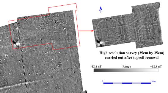
In the image above the same area surveyed at a normal resolution (25cm by 100cm) prior to the removal of the topsoil (left, survey by the AML team) can be compared with the high resolution survey (25cm by 25cm) carried out by the LRC after topsoil stripping. For further details on the 1995 surveys see Lyall, J. & Powlesland, D. J. (1996).
The technique of using high resolution surveying has been used twice more over different areas of the project zone, once after the removal of topsoil, and once on the current ground surface. In both cases, enhanced detail over the usual survey resolution was present.
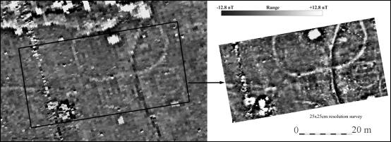
The second test area was in a different geological zone, where deep bands of sand and chalk gravel are overlain in parts by windblown sand. It was located just to the west of the area where Arnold Aspinall had carried out the initial unsuccessful geophysical tests. The effect of more magnetically susceptible ploughsoil masking underlying features is graphically demonstrated below, showing the results of two gradiometer surveys conducted at Site 010, one carried out before the removal of the topsoil, and one shortly afterwards.
The two site 010 surveys
are not directly comparable, as the initial survey had a spatial
resolution of 25cm north-south and 100 cm east-west, while the second
survey had a higher spatial resolution of 25cm in both directions.
Nevertheless, the difference in anomaly detection is quite remarkable,
especially when considering that the overburden of ploughsoil removed
from the western half of the second surveyed area was no more than
30-35cm in depth. During this second high resolution survey, it was
noticed that the difference in magnetic contrast between the filled
archaeological features and the parent sand and chalk gravel subsoil was
slight; no more than 1 or 2 nT.
The first tests were carried out in 1991 (see image below for location) and early in 1992 by Tim Carew, over 4 areas covering a total of 0.465 hectares. All of these surveys were conducted with an FM36 after the removal of the topsoil, but remaining above the archaeological strata, with the features sealed by a thin layer of hillwash and thus generally remaining invisible on the ground.
In the image above the same area surveyed at a normal resolution (25cm by 100cm) prior to the removal of the topsoil (left, survey by the AML team) can be compared with the high resolution survey (25cm by 25cm) carried out by the LRC after topsoil stripping. For further details on the 1995 surveys see Lyall, J. & Powlesland, D. J. (1996).
The technique of using high resolution surveying has been used twice more over different areas of the project zone, once after the removal of topsoil, and once on the current ground surface. In both cases, enhanced detail over the usual survey resolution was present.
The second test area was in a different geological zone, where deep bands of sand and chalk gravel are overlain in parts by windblown sand. It was located just to the west of the area where Arnold Aspinall had carried out the initial unsuccessful geophysical tests. The effect of more magnetically susceptible ploughsoil masking underlying features is graphically demonstrated below, showing the results of two gradiometer surveys conducted at Site 010, one carried out before the removal of the topsoil, and one shortly afterwards.
The two site 010 surveys
are not directly comparable, as the initial survey had a spatial
resolution of 25cm north-south and 100 cm east-west, while the second
survey had a higher spatial resolution of 25cm in both directions.
Nevertheless, the difference in anomaly detection is quite remarkable,
especially when considering that the overburden of ploughsoil removed
from the western half of the second surveyed area was no more than
30-35cm in depth. During this second high resolution survey, it was
noticed that the difference in magnetic contrast between the filled
archaeological features and the parent sand and chalk gravel subsoil was
slight; no more than 1 or 2 nT.
Although the results from the high resolution survey have already been discussed (Lyall, J. & Powlesland, D. J. (1996), there are a number of issues which were not addressed in that paper. One benefit of conducting high resolution surveys is the ability to sub-sample the data down to lower resolutions in order to test the returns from a number of different resolution settings.
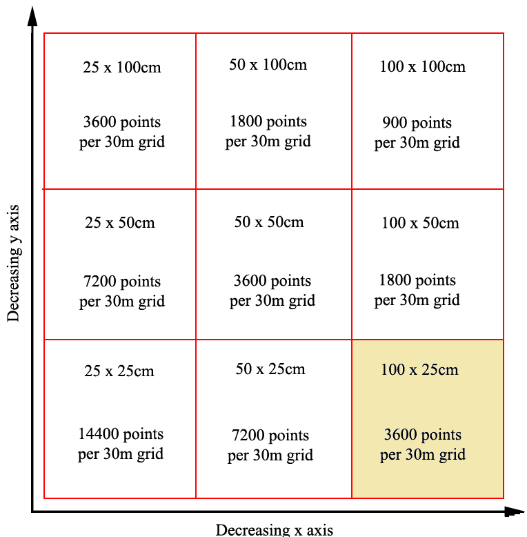
The figure above gives the 9 possible combinations of sub-samples which can be obtained from the 25 by 25 cm resolution data, as well as the number of points in a 30 metre square grid for each resolution. The standard survey resolution is shaded. During high resolution surveys, it is even more vital than normal to ensure that the machine is carried absolutely upright during the survey, as even a slight tilt of the machine would negate the attempt to achieve a true 25 cm resolution, and create striping problems in the data. For this reason it is recommended that this form of survey only be carried out by experienced operators. (Even so, note the slight zig-zag error visible where we crossed the ditch in the full resolution 25 by 25cm data).
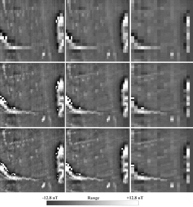
In order to test the returns from the various resolutions, an area
where anomalies of less than 50cm in diameter were detected was chosen
(Area 012AE). The location was on a raised chalky knoll, providing
excellent magnetic contrast between the chalk and the earth-filled
features. One downside was that because of the location, the
archaeological features were all plough-truncated to some degree. The
results from the nine possible combinations illustrated in above
. Note that they also demonstrate the orientation of survey
effect, noticeably changing the response of linear anomalies depending
on whether they were intersected at right angles or were aligned along
the survey orientation.
Because the English Heritage (AML) personnel had
previously carried out a normal resolution survey prior to the removal
of the ploughsoil, it was also possible to compare the results of a
normal resolution (i.e. 1m in the east-west axis and 25cm in the
north-south axis) survey, both before and after the topsoil removal.
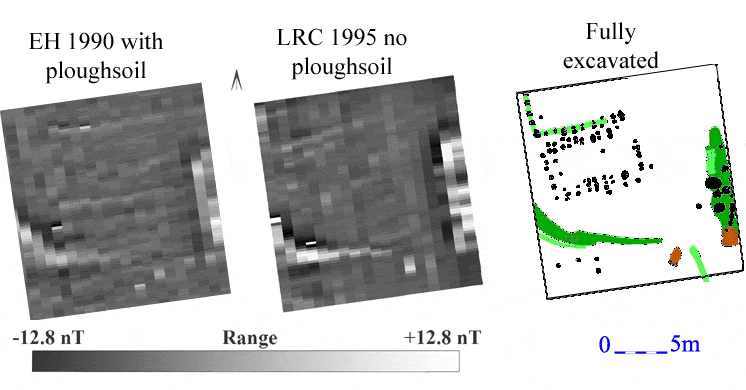
As can be seen in the figure above , the definition of the anomalies is generally better, with the linear east-west plough marks no longer visible. What proved to be a pit (just to the south-east of the eastern end of the enclosure ditch) is much more clearly defined. Although the linear slot of the post-in-trench structure is just visible in the earlier survey, it would not have been possible to interpret the anomaly as such from the normal resolution survey. There are a number of anomalies visible to the south of the post-in-trench structure, and as such would have been flagged as an area of potential archaeological interest, but they are very slight positive anomalies, and certainly could not have been interpreted as the remains of an Anglian posthole structure on this evidence alone. As a result of these findings, it is concluded that in order to detect and allow some scope for the interpretation of small anomalies, the combination of high resolution surveying with the removal of the ploughsoil is vital. As always, even using high resolution surveying does not detect all of the archaeological features, clearly demonstrated by the excavated plan in the diagram above